GSD Calculator – Oblique Camera Calculation
Help section GSD Oblique
Version 5.30 – PhaseOne PAS880/880i
Version 5.10 – UltraCam Osprey 4.1
Version 503 – Ultracam Osprey Mark 3 Premium /Essential
Version 510 – IGI UrbanMapper / Pentacam
Version 515 – Leica CityMapper/ Pentacam
Back to General Help – Home
| |
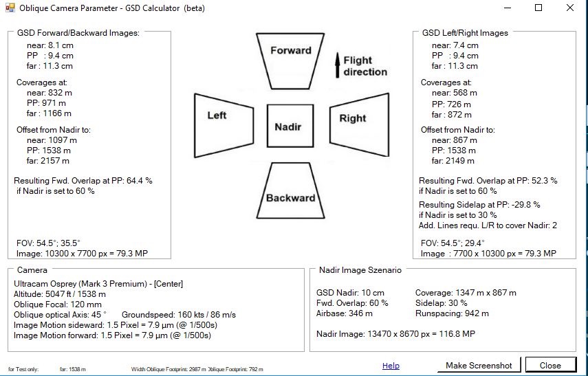
Press “Oblique” Button to get Oblique Calculation |
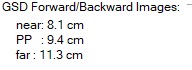 |
GSD section show the resulting GSD at
|
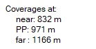 |
show the corresponding coverage of the image at:
|
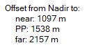 |
Offset from Nadir show the distances of the mage in relation to the Nadir of the vertical image (Maltese Cross configuration):
|
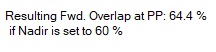 |
Resulting forward overlap of the oblique image at the PP –Principal Point – when using the Nadir Image configuration as predefined in the GSD Calculator main window. |
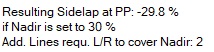 |
Resulting sidelap of the oblique image at the PP –Principal Point – when using the Nadir Image configuration as predefined in the GSD Calculator main window.
It also show the amount of additional flight lines required to Left/Right to cover the Nadir of the vertical image with a certain overlap. |
| |
Field of View and Image size of the corresponding oblique lens cones |
| |
Shows the camera parameters, such as flight altitude, focal lengths of the oblique lenses cones, and the optical axis of the oblique cameras.
Additionally the expected image motion is calculated, based on the Groundspeed settings of the main window of the GSD calculator (default 160 kts). The image motion is display for an expected exposure time of 1/500 second. In case of a Ultracam Osprey camera, shortest shutter time is 1/750 second. |
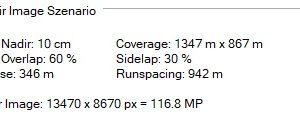 |
Display the current settings for the NADIR image |
| |
Create a screenshot of the Window to implement into other programs. |
| Help | opens Help Page |
 |
|
 |
|
Back to General Help – Home