Leica has updated their CityMapper line with the all-new CityMapper-2.
[download your free copy of GSD Calculator here]
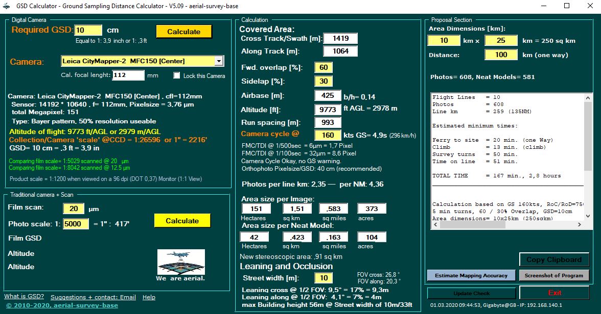
The version 2 of the city mapper is specifically designed for airborne urban mapping and creating „digital -twins“ of cities.
It twice the data collection performance for generating urgent 3D data sets. The incredible hybrid machine captures by two nadir (RGB/NIR) and four oblique 150 MP sensors (45°) with a frame rate (camera cycle) of 0.8 seconds.
Backlight illumination (BSI) Bayern pattern CMOS chip with 83dB dynamic range.
New designed interchangeable lenses (7,5 f-stops) including mechanical Forward-Motion-Compensation (FMC) will eliminate image blur a lot in almost all mission profiles.
- The CityMapper-2S running a 122mm lens produce 5 GSD @ 1.500m AGL (4.900′)
- The CityMapper-2H running a 146 mm lens produce 5 GSD @ 1.900m AGL (6.230′)
It’s called hybrid because of the build-in new generation 2 MHz PPR HYPERION LiDAR which offers Multiple-Pulses-in-the-Air (MPiA – gateless!), the Hyperion specific oblique scan pattern with max 3cm accuracy based on USGS LiDAR quality Level 0.
Build-in OEM7 GNSS+SPAN CNUS5-H 500Hz Class 5- fibre optical IMU(no export license requirred!) and perfectly fit in PAV100 gyro mount.
All Hyperion LiDARs offer up to 15 returns, Intensity recording, Full Waveform, Real Time Waveform Analysis and Ambiguity Resolution for targets in multiple simultaneous MPiA zones and 20…40° FOV. Data processing will be done in HxMap.
read more at Leica-Geosystems
Download DataSheet Leica CityMapper-2 (MFC150)
download your free copy of GSD Calculator here
updated March 08, 2020: CityMapper now separeted in 2H and 2S version in GSD Calculator, thanks to Poul.