GSD Calculator v5.65
Well, it’s been a while since we had any updates on the GSD Calculator—but today, we’re sharing a few fresh insights from Intergeo 2025.
Things have been incredibly busy lately, mostly due to our product developments at iMAR Navigation, where I work for. Our iCORUS Airborne Gravimeter is performing well, and we’re in the middle of launching our new gyroscopic navigation system for Horizontal Directional Drilling. On top of that, our high-performance GNSS/IMU technology for industrial and defense applications are demanding a lot of time and attention.
DOWNLOAD your free copy of GSD Calculator here
What’s new from INTERGEO?
New at INTERGEO 2025: Vexcel’s UltraCam Merlin 5.0 and Dragon 4.2, PhaseOne’s IXM-RS250, and IGI’s CM-1
Vexcel Imaging unveiled its cutting-edge UltraCam Merlin 5.0, a state-of-the-art aerial camera designed for precision nadir mapping. Introduced at INTERGEO, it sets a new benchmark in photogrammetry.
Key Features and Benefits of the UltraCam Merlin 5.0:
- 37,500-pixel wide image swath with true nadir: Delivers ultra-high-resolution imagery across vast areas.
- Three interchangeable lens kits: f90, f120, and f150 – allowing flexible deployment across various flight altitudes.
- Sony IMX811 CMOS sensors: 247 megapixels per sensor, purpose-built for photogrammetric applications.
- Adaptive Motion Compensation (AMC): Eliminates motion blur in real time – especially valuable during high-speed flights.
- Rapid image capture: One image every 0.7 seconds – ideal for efficient aerial missions.
Also new from Vexcel is the UltraCam Dragon 4.2, a hybrid aerial imaging and LiDAR system tailored for complex urban mapping. It merges high-resolution visual data with powerful 3D point cloud acquisition for comprehensive spatial analysis.
The UltraCam Dragon 4.2 is a hybrid system that combines a high-performance aerial camera with a 2.4 MHz RIEGL waveform LiDAR scanner, enabling simultaneous image capture and point cloud acquisition.
Key Features:
• Five scan lines, including a true nadir scan line – ideal for capturing data in dense urban environments and narrow city corridors.
• Two nadir cameras: RGB and NIR (near-infrared)
• Four oblique RGB cameras: Each equipped with Sony IMX811 CMOS sensors delivering 19,136 × 12,736 pixels – the same high-resolution sensors used in the UltraCam Merlin 5.0.
• Capture rate: A complete image set every 0.7 seconds – ensuring high mission efficiency.
• 35% improved flight line efficiency compared to previous models – faster data collection without compromising quality.
The UltraCam Dragon 4.2 was officially presented at INTERGEO in Frankfurt, with Slagboom & Peeters as the launch customer – renowned for their precision aerial mapping.
Looking at the bread-and-butter standard busibness of nadir image capture, the UltraCam Eagle Mark 3 with its 26,450-pixel swath was already a powerhouse back in 2021. Then came the Merlin 4.2 in 2023, and now the Merlin 5.0 with a 37,500-pixel swath, Adaptive Motion Compensation (AMC), a halved capture interval, and upgraded CMOS sensors—truly impressive progress.
Of course, it goes without saying that UltraMap 6.x offers a professional-grade software suite that delivers fast, streamlined, and high-quality production of true orthophotos and 3D modeling—including 3D TINs, point clouds, digital surface models (DSM), and digital terrain models (DTM)—all fully automated.
What continues to impress me is how UltraMap seamlessly merges data from multiple flight missions into one cohesive, comprehensive product. That level of integration is truly remarkable.
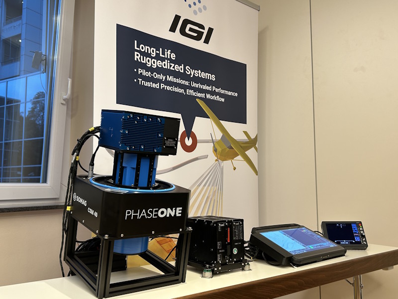
IGI CM-1: A Modular Aerial Camera System for Infrastructure Mapping
The IGI CM-1 is a modular aerial camera system developed by IGI, built on Phase One technology and specifically designed for infrastructure mapping projects.
Key Features:
- Utilizes high-quality medium-format sensors of Phase One for precise imaging.
- Modular design: Highly configurable for a wide range of applications, including:
- Roadway surveying, Railway corridor mapping, Power line inspection
- Seamless integration with the IGI ecosystem: When paired with IGIplan mission planning, CCNS-5 guidance and sensor management, and AEROcontrol GNSS/IMU, the system delivers the high image quality required for photogrammetric analysis and GIS applications.
- Shutterless operation supported !
- Ultra-fast image capture: Standard rate of 3.3 Hz, with a maximum of 5 Hz!
- Achieves 1 cm GSD at 120 knots, 1,500 ft altitude, and 80% forward overlap—previously a capability reserved for drones.
- Delivered with the Somag CSM 40 gyro-stabilized suspension mount.
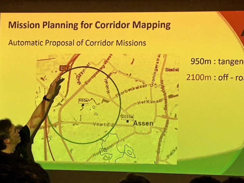
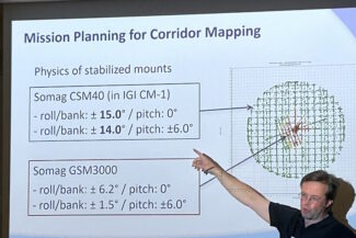
What truly impressed me is how this system breaks away from traditional flight planning layouts. Thanks to the camera’s design—and in combination with IGIplan and the Somag CSM 40—you can now fly curved flight paths. This is a game-changer for corridor mapping, significantly reducing flight time. IGI even controls the mount dynamically, allowing the aircraft to follow roads, highways, or rail lines directly. Time savings of over 70% compared to conventional methods are possible.
PhaseOne iXM-RS250
Phase One’s showcase is the new iXM-RS250, the company’s flagship aerial camera. Combining ultra-high resolution with compact efficiency, the iXM-RS250 delivers the widest coverage from a single sensor, enabling faster missions, lower fuel costs, and maximum productivity. With exclusive support for IIQ-X compression, users benefit from up to 90% smaller file sizes compared to TIFF, without compromise on image quality. Rounding out the lineup is the upcoming software release of iX Process 3.0, Phase One’s image processing software with component support and the ability to create projects from IIQ files. The new release introduces faster quality control, visual inspection of acquired data, and completion checks immediately after data capture. With automated quality checks on overlap, GSD, and other acquisition attributes, as well as improved filter options, iX Process 3.0 ensures greater efficiency, accuracy, and reliability in managing aerial data acquired by flexible customized camera system setups. (from Press Release)
Great! I’m looking forward to hearing more about Leica’s multi-head mapper. It sounds like a fascinating addition to their portfolio—especially if it’s geared toward high-efficiency aerial or corridor mapping.